AirMap

1 avis

Description Courte

Description

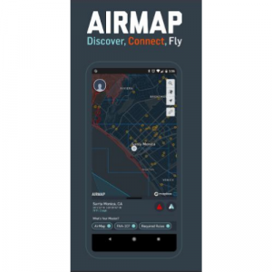
AirMap is a global leader in airspace management software systems for drones. We help regional and national airspace authorities operate safely and efficiently. We help the defense sector and public agencies use drone solutions to keep people safe. We also work with forward-thinking enterprises to innovate new commercial opportunities.

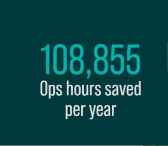
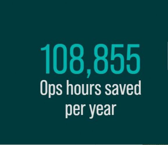
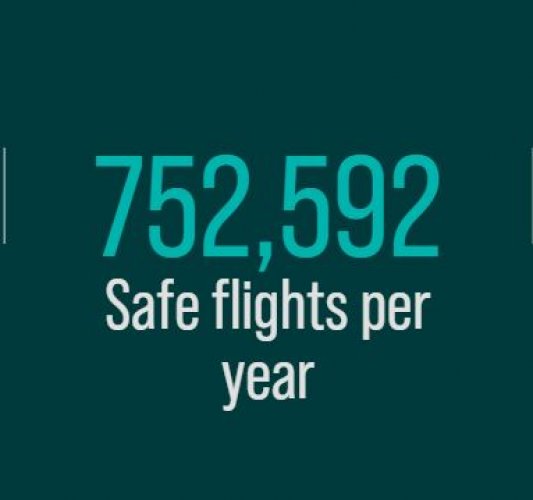
108,855 Ops hours saved per year

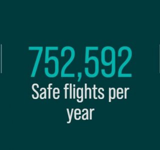
752,592 Safe flights per year

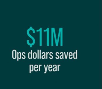
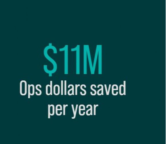
$11M Ops dollars saved per year

Manage your Airspace

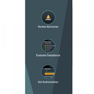
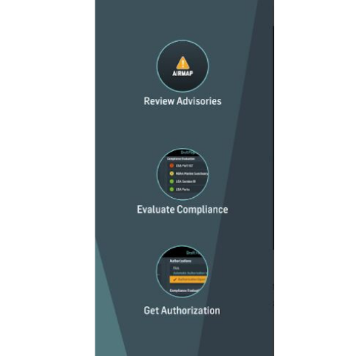
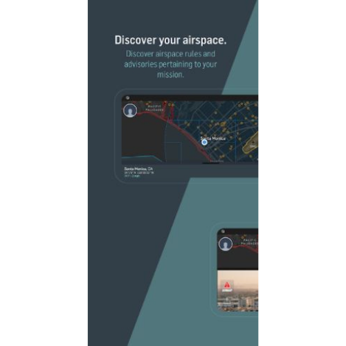
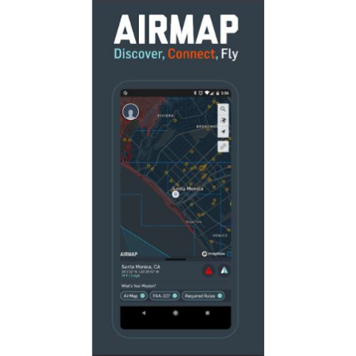
Whether you’re an operator seeking flight permission, an ANSP establishing airspace rulesets, or an enterprise looking for beyond visual line-of-sight inspection solutions, AirMap provides an unrivaled level of airspace intelligence and control.

AirMap is the future of airspace management.

We help customers thrive in the drone economy with the world’s most comprehensive suite of airspace intelligence.

Powerful, simple, affordable solutions that simplify missions.
We provide robust, intuitive, and cost-effective data, insights, platforms and apps to streamline missions and tasks.
Manage, protect, innovate.
Manage risk with data insights, protect your people and assets, and innovate new airspace products.

Spécifications

  • Consultancy, Software Solutions
  • Autel, Delair, DJI, IdeaForge, Parrot, Skydio, Wingtra, Zipline
  • Canada, France, Germany, India, United Kingdom,
  • Aerial Photography, Archeology & Monuments, Construction & Real Estate, Disaster Management / First responders, Drone Delivery, Éducation, Environment & Wildlife, Forestry & Agriculture, Infrastructure & Transport, Leisure & Hobby, Mining & Exploration, Power & Utilities, Science & Research, Security & Law Enforcement, Surveillance & Mapping
  • Air
  • Beyond Visual Line of Sight (BVLOS), Extended Visual Line of Sight (EVLOS), Line of Sight (LOS)
  • Desktop Mac Version, Desktop Windows PC Version, Mobile Andriod Version, Mobile iOS Version
  • Acoustic, Echo Sounder, GPR, Image Sensor, LiDAR, Methane Detector, Multi Spectral, Thermal Sensor, Acoustic, Echo Sounder, GPR, Image Sensor, LiDAR, Methane Detector, Multi Spectral, Thermal Sensor
  • 2
  • 80 to 90 %, 90 to 100 %, 80 to 90 %, 90 to 100 %
  • 90 to 100 %, 90 to 100 %
  • Battery Warning, Checklist, GeoFencing, Low GPS, Signal Lost
  • English, French, German, Spanish

Avis & Discussions

Notez-nous
1 Discussions
Voir tout

Produit ajouté à la comparaison

Autres Produits / Services

AirMap
AirMap
AirMap
AirMap
AirMap
Prix: $3,500
AirMap
Prix: $750

Voir le contact

S3 Tech Solution

Éducation

Bike

Education Institute

Aerial Photography, Construction & Real Estate, Drone Delivery, Éducation, Mining & Exploration, Power & Utilities, Security & Law Enforcement

India

Guam, Guernsey, Guadeloupe, Guatemala, Algeria, India

76433333

sfdfad faf dsfddsf asdfd fsdfa best b2b website sfdfad faf dsfddsf asdfd fsdfa best b2b website sfdfad faf dsfddsf asdfd fsdfa best b2b website sfdfad faf dsfddsf asdfd fsdfa best b2b website

Contacter le vendeur / Demander un devis

AirMap
AirMap
- +
superman22 Education Institute